Paper Earth: Kyoto Station heat, summer vs. winter
NASA MODIS land surface temperature around Kyoto Station, Japan, on two dates. Press a date to switch.

Kyoto Station
Grey stripes = no data (cloud or a failed retrieval). Missing pixels are left empty and never filled in.
Color scale (Kelvin; 290 K ≈ 17 °C, 320 K ≈ 47 °C)
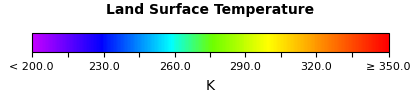
What this shows: in summer the built-up Kyoto basin around the station is among the warmest ground in the area (orange, roughly 305–315 K), while the wooded hills look cooler (yellow-green). In winter the whole area drops to roughly 270–285 K (green) and the city stands out much less.
This is land surface temperature, not air temperature
MODIS measures how hot the ground and roof surfaces are from space (skin temperature). It is not the air temperature from a weather station. Each pixel covers about 1 km × 1 km, so it cannot show the temperature of a single building or street.
Data
- Product
- MODIS/Terra Land Surface Temperature, Daily L3 Global 1 km (MOD11A1), daytime overpass about 10:30 local time
- Delivered by
- NASA GIBS, layer
MODIS_Terra_Land_Surface_Temp_Day - Date shown
- 2025-08-18
- Unit
- Kelvin (color-scaled image, not raw values)
- Area
- 34.6–35.4°N, 135.4–136.2°E (about 89 × 73 km, WGS84)
- Resolution
- ~1 km native; the 512 px picture is upsampled, so blocks are 1 km cells
- Source
- Open this exact image from NASA GIBS · MOD11A1 v061 (LP DAAC) · GIBS API